


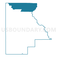
3-Voting District, Highlands County, Florida
About
Outline

Summary
| Unique Area Identifier | 553595 |
| Name | 3-Voting District |
| County | Highlands County |
| State | Florida |
| Area (square miles) | 126.96 |
| Land Area (square miles) | 123.40 |
| Water Area (square miles) | 3.56 |
| % of Land Area | 97.19 |
| % of Water Area | 2.81 |
| Latitude of the Internal Point | 27.61678820 |
| Longtitude of the Internal Point | -81.33557270 |
Maps


Graphs
Select a template below for downloading or customizing gragh for 3-Voting District, Highlands County, Florida


Neighbors
Neighoring Voting District (by Name) Neighboring Voting District on the Map
- 1-Voting District, Highlands County, FL
- 12-Voting District, Highlands County, FL
- 16.2-Voting District, Highlands County, FL
- 16A-Voting District, Highlands County, FL
- 1A-Voting District, Highlands County, FL
- 2-Voting District, Highlands County, FL
- 22.2-Voting District, Highlands County, FL
- 539-Voting District (Frostproof), Polk County, FL
- 540-Voting District (Indian Lakes Estates), Polk County, FL
- 6-Voting District, Highlands County, FL
- 89-Voting District, Osceola County, FL
- P02-Voting District, Okeechobee County, FL
Top 10 Neighboring County Subdivision (by Population) Neighboring County Subdivision on the Map
- Sebring CCD, Highlands County, FL (40,776)
- Avon Park CCD, Highlands County, FL (32,790)
- Frostproof CCD, Polk County, FL (12,533)
- North Okeechobee CCD, Okeechobee County, FL (8,591)
- South and East Osceola CCD, Osceola County, FL (7,194)
Top 10 Neighboring Place (by Population) Neighboring Place on the Map
Top 10 Neighboring Unified School District (by Population) Neighboring Unified School District on the Map
- Polk County School District, FL (602,095)
- Osceola County School District, FL (268,685)
- Highlands County School District, FL (98,786)
- Okeechobee County School District, FL (39,996)
Top 10 Neighboring State Legislative District Lower Chamber (by Population) Neighboring State Legislative District Lower Chamber on the Map
- State House District 79, FL (187,203)
- State House District 66, FL (162,026)
- State House District 77, FL (147,455)
Top 10 Neighboring State Legislative District Upper Chamber (by Population) Neighboring State Legislative District Upper Chamber on the Map
Top 10 Neighboring 111th Congressional District (by Population) Neighboring 111th Congressional District on the Map
- Congressional District 12, FL (842,199)
- Congressional District 15, FL (813,570)
- Congressional District 16, FL (797,711)
Top 10 Neighboring Census Tract (by Population) Neighboring Census Tract on the Map
- Census Tract 438, Osceola County, FL (7,194)
- Census Tract 9604, Highlands County, FL (7,150)
- Census Tract 9603, Highlands County, FL (4,448)
- Census Tract 9610, Highlands County, FL (4,432)
- Census Tract 9602, Highlands County, FL (4,246)
- Census Tract 157.02, Polk County, FL (4,188)
- Census Tract 9101.02, Okeechobee County, FL (2,821)
- Census Tract 9601.01, Highlands County, FL (2,593)
- Census Tract 9601.02, Highlands County, FL (1,449)
- Census Tract 9801, Highlands County, FL (0)
Top 10 Neighboring 5-Digit ZIP Code Tabulation Area (by Population) Neighboring 5-Digit ZIP Code Tabulation Area on the Map
- 33825, FL (24,942)
- 33870, FL (20,601)
- 34972, FL (20,180)
- 33898, FL (15,355)
- 33843, FL (11,093)
- 33857, FL (1,728)